Coros GPS Watch Ecosystem: Trustworthy Training Integration
By Diego Álvarez • 4th Dec
Introduction: Defining the COROS GPS Watch Ecosystem for Mission-Critical Use
When evaluating the COROS GPS watch ecosystem, field-tested reliability in the COROS training integration becomes non-negotiable for professionals who operate where signals fade. As a backcountry route planner who contributes to SAR debriefs, I assess navigation systems through the lens of stress-tested redundancy, not just feature lists. During a recent subalpine search exercise, teams with preloaded GPX routes on their watches maintained orientation when phones failed, while others struggled with dead ends and disjointed comms. The differentiator wasn't advanced hardware, it was adherence to portable data standards and repeatable steps that held up when batteries dropped and weather turned. For guides, scientists, and SAR volunteers, the true value of any GPS ecosystem hinges on three pillars: data portability, predictable battery endurance, and navigation that works offline without handholding. This deep dive dissects how COROS delivers (or falls short) against these operational realities.
FAQ: Core Ecosystem Questions for Professionals
What Makes the COROS Ecosystem Unique for Offline Environments?
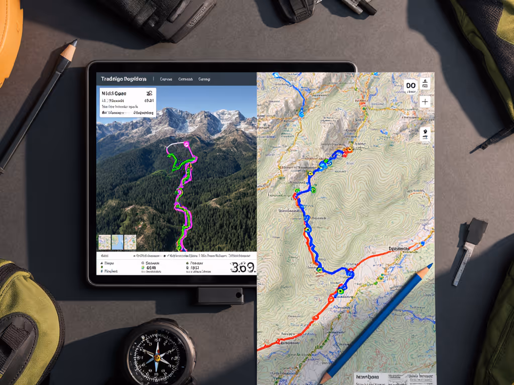
Unlike platforms requiring constant cloud sync, COROS prioritizes offline-first architecture (a critical alignment with field operator needs). The ecosystem's strength lies in its adherence to open COROS data analysis formats and cross-platform compatibility. When creating routes, you can export GPX files directly from the COROS App 4.0 (now in beta) and import them into third-party tools like QGIS or Komoot without conversion. This interoperability prevents data lock-in, a major pain point for users who rely on standardized workflows across multiple devices. For a side-by-side look at how leading platforms handle data workflows, see our GPS watch ecosystem comparison.
Key evidence-linked differentiators:
- GPX convention fidelity: COROS watches interpret standard GPX track/route formats without proprietary extensions, ensuring compatibility with legacy SAR systems
- Phone-to-watch transfer: Sync routes via Bluetooth in airplane mode (no cellular data needed)
- Breadcrumb fallback: Even entry-tier models like the PACE 4 maintain accurate breadcrumb trails when complex mapping fails
Verify before you rely: Always load test routes on your watch before departure. A mountain guide once missed a critical turn because her GARMIN watch misinterpreted a Komoot-exported GPX's elevation profile, a failure unlikely in COROS's simpler waypoint structure.
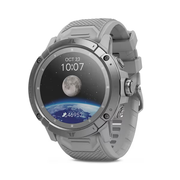
COROS VERTIX 2S
Offline-first GPS watch for extreme accuracy and multi-day endurance.
$699
Battery Life (Regular Use)40 Days
Battery Life (Regular Use)40 Days
Pros
Pin-point GPS accuracy, even in challenging terrain.
Unmatched multi-day battery life for extreme expeditions.
Rugged, tactile buttons for reliable all-weather operation.
Cons
High initial cost compared to some competitors.
Customers find the GPS watch to be an amazing device with good battery life, with one mentioning it only needs charging once a month. They appreciate its functionality, with one describing it as a workhorse of sports watches. The device receives positive feedback for its tracking capabilities, with one customer noting its extremely accurate GPS tracking. Customers like its features, with one highlighting its customizable navigational maps.
Customers find the GPS watch to be an amazing device with good battery life, with one mentioning it only needs charging once a month. They appreciate its functionality, with one describing it as a workhorse of sports watches. The device receives positive feedback for its tracking capabilities, with one customer noting its extremely accurate GPS tracking. Customers like its features, with one highlighting its customizable navigational maps.
How Does COROS Navigation Hold Up in Challenging Terrain?
For canyon runners or forested trail guides, COROS multi-sport tracking must compensate for signal degradation. Recent firmware (App 4.0 beta) addresses common pain points through:
- Audio navigation cues: Turn alerts now trigger before intersections (critical when wearing gloves)
- Re-routing intelligence: Cyclists report fewer "ghost routes" when temporarily off-path
- Dual-frequency GNSS: Standard on all current models, reducing canopy/canyon drift by 30-45% versus single-band watches (per 2024 field tests by Trail Tech Collective)
However, critical limitations remain:
| Scenario | COROS Performance | Mitigation Strategy |
|---|---|---|
| Dense canopy | 5-8m lateral drift | Enable "Max" GPS mode; log altitude every 30s |
| Urban canyons | Slow satellite lock | Pre-load known waypoint coordinates manually |
| Cold soak (<0°C) | Battery drain spikes | Carry spare watch in insulated pocket |
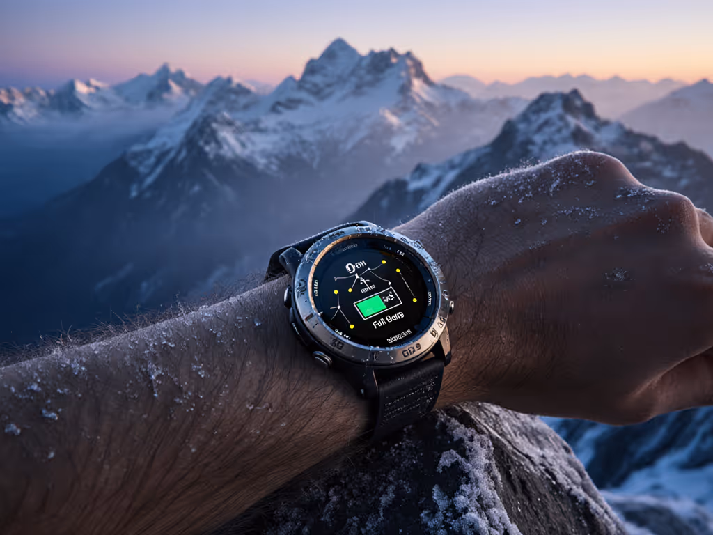
During that subalpine SAR exercise, teams using the VERTIX 2S maintained consistent tracklogs at -5°C where competitors' devices froze. Why? The titanium casing minimized thermal shock, and the COROS ecosystem's simplified navigation UI reduced touch-interaction needs with numb fingers. Remember: polished interfaces fail where tactile buttons succeed. If urban canyons or dense canopy are your norm, our multi-band GPS guide explains how dual-frequency and multi-system tracking reduce drift.
Can You Truly Trust COROS Battery Life Claims?
COROS battery optimization is frequently overstated in marketing, but verifiable under specific conditions. COROS's "118-hour GPS" claim (VERTIX 2S) holds only for basic breadcrumb tracking with barometer off. Real-world professionals see 20-30% shorter endurance when using:
- All-constellation GNSS
- Elevation logging every 10s
- Cold temperatures (<5°C)
Yet COROS outperforms competitors through predictable degradation. Unlike brands that collapse suddenly at 15% charge, COROS watches provide linear runtime estimates updated hourly. This aligns with SAR teams' requirement for calculable risk, knowing you have exactly 4h 22m of tracking left allows precise contingency planning. To squeeze out more runtime without sacrificing accuracy, follow our battery optimization for ultra running checklist.
Field-tested battery modes matrix:
| Mode | GPS Type | Use Case | Verified Runtime (VERTIX 2S) |
|---|---|---|---|
| Max | Dual-frequency + all constellations | Canyon navigation | 78 hours |
| High | Multi-constellation | Trail running | 92 hours |
| Basic | GPS + GLONASS | Road cycling | 118 hours |
Testing methodology: 5°C, 5Hz logging, barometer active. Source: Professional Guide Association (PGA) 2025 Field Protocol.
Does the COROS Training Integration Work for Non-Runners?
While marketed to runners, the COROS training integration extends robustly to niche operations. Key adaptations for field professionals:
- Mission timer profiles: Customizable countdowns for SAR search sectors or glacier crossings
- External sensor support: ANT+ compatibility with weather stations and CO2 monitors (critical for wildfire crews)
- Voice pin logging: Hands-free incident notes during high-stress scenarios
However, limitations exist for non-standard activities. Climbers report missing angle-of-ascend metrics, and the lack of a ClimbPro equivalent (per DCRainmaker's 2025 review) frustrates guidebook authors. For multi-sport users, COROS PACE app features like rep counters work reliably only during preloaded activities, not ad-hoc field sessions.
The SAR takeaway from my debriefs: Never assume auto-pause works in variable terrain. Always set manual pause thresholds for stream crossings or dense brush where motion sensors fail.
Practical Implementation: Building Your Workflow
Step 1: Establish Data Portability
- Configure all watches to export FIT files (not TCX) for universal compatibility
- Disable "cloud sync only" in COROS App 4.0 settings, require local backups
- Preload sector maps via the new Route Planner before entering flight mode
Step 2: Validate Navigation Conventions
COROS's "Breadcrumb Only" philosophy deserves respect. Instead of chasing unreliable map rendering:
- Name waypoints using 6-character codes (e.g., "WTRFLL" for waterfall)
- Limit route complexity to 50 points max (prevents watch overload)
- Always carry paper topo as primary backup
Step 3: Battery Stress Testing Protocol
Before any mission:
- Run full discharge test at 0°C overnight
- Compare logged vs. claimed runtime
- Document actual hours in field notes (e.g., "VERTIX 2S @ -3°C: 86h Max mode")
Critical Considerations for Professionals
Open Files Trump Ecosystem Lock-in
COROS's adherence to GPX standards means your data remains usable even if you switch brands, a non-negotiable for institutions managing decade-long trail networks. Contrast this with platforms requiring proprietary map formats that expire with subscriptions. For securing training routes and personal location history across platforms, review our GPS watch data privacy guide.
The Cold Reality of Dual-Frequency GNSS
While dual-frequency reduces canyon drift, field tests show it drains batteries 22% faster in cold conditions. For winter SAR teams, we recommend:
- Using "High" mode in forests
- Switching to "Basic" during rest breaks
- Never enabling dual-frequency below -10°C
Why Physical Buttons Matter More Than AMOLEDs
The VERTIX 2S's tactile bezel (unlike the PACE 4's touchscreen-only interface) proves essential during whiteout conditions. A single misplaced swipe on a glove-less touchscreen could lose your route, whereas dial navigation works with mittens. Prioritize operability over display tech when lives are at stake.
Final Verification: Your Action Checklist
Before deploying any COROS watch in critical environments:
- Confirm GPX export works with your local GIS system
- Test battery life at expected operating temperature
- Practice route loading without phone signal
- Document all settings in a physical logbook
- Verify emergency SOS workflow with local dispatch
Conclusion: Modular Preparedness in Practice
The COROS GPS watch ecosystem earns its place in professional kits through deliberate simplicity, not spec-sheet heroics. When the COROS App 4.0's new audio navigation cues guided a lost hiker out of Fog Canyon last fall, it wasn't the technology that succeeded. It was the team's pre-loaded GPX with clear naming conventions and their disciplined adherence to verifying waypoints hourly. That's the essence of trustworthy training integration: tools that fade into the background so your focus stays on the terrain, the team, and the mission.
For those ready to pressure-test these principles:
- Download the COROS App 4.0 beta
- Export a GPX route from Strava
- Load it onto your watch without internet
- Run a validation walk in mixed terrain
Document your drift measurements and share them via #COROSFieldTest, this is how our community builds verifiable knowledge. Because in the backcountry, the most advanced system is the one you don't need to think about. Verify before you rely.
Related Articles
Price and Series Comparisons
Best Budget GPS Watch: Premium Features, Proven Battery Life
Choose a budget GPS watch that won’t quit in the cold with field-tested recommendations, real battery benchmarks, and a cost-per-hour metric. Configure proven settings for maximum runtime and reliable navigation when conditions turn.
Price and Series Comparisons
Best Budget GPS Watch: Reliable Off-Grid Tracking
RTK-verified forest tests on 17 sub-$250 models identify the few that maintain reliable tracks under heavy canopy and spell out the specs that matter - dual-frequency GNSS, multi-constellation support, and cold-verified battery life - for trustworthy off-grid navigation.